Comanche & Indian Gap Railroad 2018: Difference between revisions
No edit summary |
|||
| (5 intermediate revisions by the same user not shown) | |||
| Line 1: | Line 1: | ||
[[Category:History]] | |||
== Spring Meet == | == Spring Meet == | ||
=== Robert Willis Drone Photos === | === Robert Willis Drone Photos === | ||
Robert Willis | Robert Willis used a high-flying drone to capture the following images of the Comanche & Indian Gap Railroad during the Spring Fling, April 2018. Click on the photos to enlarge (actually, click, then click again). | ||
<gallery widths=800px heights=500px perrow=1> | <gallery widths=800px heights=500px perrow=1> | ||
File:CIG Spring Meet 2018Apr MexicanHat RobertWillis.jpg|Switching operations well underway at Mexican Hat on the Comanche & Indian Gap RR. The top of the wye is the west end of the Houston East & West Texas RR (The "Rabbit"). The left end of the wye leads to Tlaquepaque. | File:CIG Spring Meet 2018Apr MexicanHat RobertWillis.jpg|Switching operations well underway at Mexican Hat on the Comanche & Indian Gap RR. The top of the wye is the west end of the Houston East & West Texas RR (The "Rabbit"). The left end of the wye leads to Tlaquepaque. | ||
File:CIG Tlaquepaque RobertWillis 2018Apr.jpg|The big loop on the west end of the Comanche & Indian Gap RR. The area covered by trees next to the caboose is Tlaquepaque. Mexican | File:CIG Tlaquepaque RobertWillis 2018Apr.jpg|The big loop on the west end of the Comanche & Indian Gap RR. The area covered by trees next to the caboose is Tlaquepaque. Mexican Hat is just to the right of the wye. The HEWT starts on the left side of the wye. Curving to the left from Tlaquepaque you reach Summit, then straight into Anasazi, then continue to cross the HEWT and on to Gotebo. After crossing the CIG, the HEWT moves to the left and then up into West Yard and Springerville. You can just make out Indian Gap and the Pickard homestead in the upper right of the photo. | ||
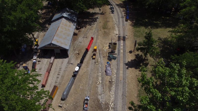
File:IndianGapYard CIG RobertWillis 2018Apr.jpg|View of the Indian Gap yard and the steaming bays and transfer table of the Comanche and Indian Gap RR. The east end of the Houston East & West Texas RR (HEWT) also starts here at Indian Gap. | File:IndianGapYard CIG RobertWillis 2018Apr.jpg|View of the Indian Gap yard and the steaming bays and transfer table of the Comanche and Indian Gap RR. The east end of the Houston East & West Texas RR (HEWT) also starts here at Indian Gap. | ||
File:IndianGapYard overhead CIG RobertWillis 2018Apr.jpg|An overhead view of the Indian Gap yard and shops, along with the steaming bays and the transfer table. | |||
File:ComancheYard CIG RobertWillis 2018April.jpg|A view of the Comanche Yard, which is on the east end of the Comanche & Indian Gap Railroad. | |||
File:ComancheYard CIG ABA RobertWillis 2018Apr.jpg|Trains waiting at Comanche Yard. | |||
</gallery> | </gallery> | ||
Latest revision as of 16:39, 1 September 2020
Spring Meet
Robert Willis Drone Photos
Robert Willis used a high-flying drone to capture the following images of the Comanche & Indian Gap Railroad during the Spring Fling, April 2018. Click on the photos to enlarge (actually, click, then click again).
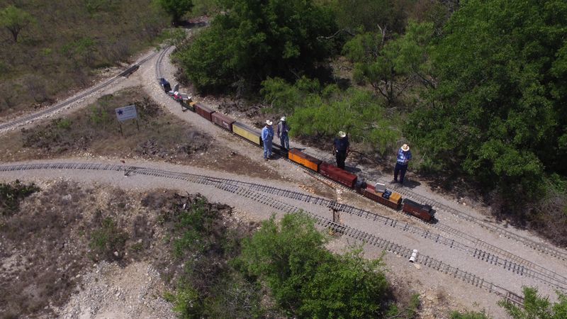
Switching operations well underway at Mexican Hat on the Comanche & Indian Gap RR. The top of the wye is the west end of the Houston East & West Texas RR (The "Rabbit"). The left end of the wye leads to Tlaquepaque.
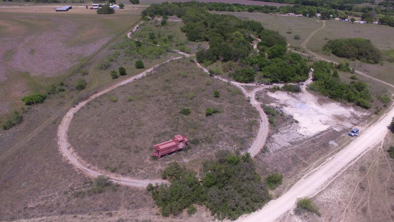
The big loop on the west end of the Comanche & Indian Gap RR. The area covered by trees next to the caboose is Tlaquepaque. Mexican Hat is just to the right of the wye. The HEWT starts on the left side of the wye. Curving to the left from Tlaquepaque you reach Summit, then straight into Anasazi, then continue to cross the HEWT and on to Gotebo. After crossing the CIG, the HEWT moves to the left and then up into West Yard and Springerville. You can just make out Indian Gap and the Pickard homestead in the upper right of the photo.
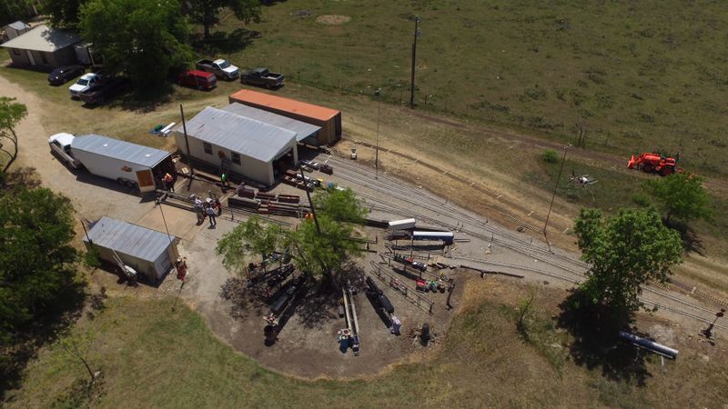
View of the Indian Gap yard and the steaming bays and transfer table of the Comanche and Indian Gap RR. The east end of the Houston East & West Texas RR (HEWT) also starts here at Indian Gap.
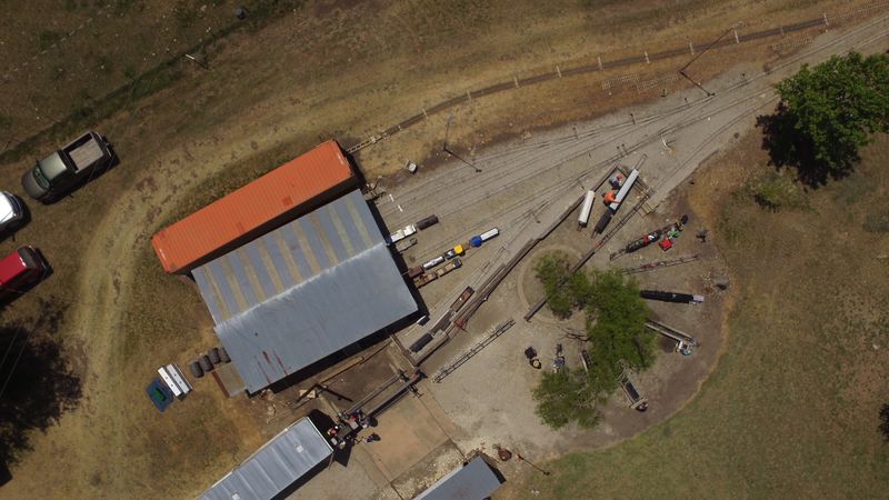
An overhead view of the Indian Gap yard and shops, along with the steaming bays and the transfer table.
A view of the Comanche Yard, which is on the east end of the Comanche & Indian Gap Railroad.
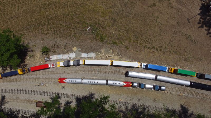
Trains waiting at Comanche Yard.


